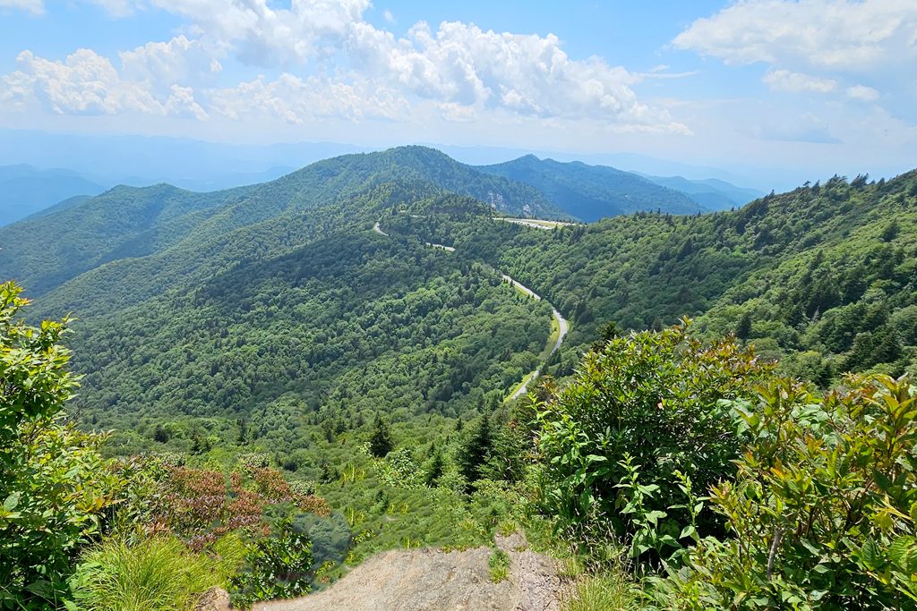
The Blue Ridge Parkway is America’s favorite drive — 469 miles of stunning mountain scenery connecting Shenandoah National Park in Virginia to Great Smoky Mountains National Park in North Carolina. And the stretch near Waynesville contains some of the Parkway’s absolute best stops, including its highest point. From Smoky Mountain Dream, you can reach the Parkway in just 10 minutes.
I’ve driven this section of the Parkway hundreds of times in every season, and I share current conditions — road closures, fog, fall color status — with guests throughout their stay. This guide covers every stop worth making between Milepost 410 and 460, organized so you can drive it in either direction and hit the highlights.

Planning Your Parkway Drive
Before you head up, a few things worth knowing. The speed limit is 45 mph everywhere, and it should be — this road was designed for savoring, not rushing. There are no gas stations, restaurants, or stores on the Parkway itself, so fill your tank and pack food and water before leaving Waynesville. Cell service is spotty to nonexistent on most of this stretch, so download offline maps in advance.
The full drive from Milepost 410 to 460 takes about 2-3 hours with stops — longer during fall foliage season when the overlooks are busier. You can easily fill a half day or a full day depending on how many trails you hike. I recommend starting early in the morning for the best light, fewer crowds, and a better chance of seeing wildlife.
Road Closures
Sections of the Parkway close regularly for weather — ice, snow, fog, and fallen trees all trigger closures, especially from November through April. Before heading out, check the real-time road status at the NPS road closure map or call the recorded road status line at (828) 298-0398. I also check conditions for guests and can usually tell you what to expect based on the weather.
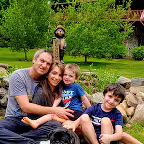
Smoky Mountain Dream is 10 minutes from the Blue Ridge Parkway — closer than almost any other cabin rental in the area. 5 bedrooms, sleeps 10, with a wraparound deck for unwinding after a day on the Parkway. Check availability →
The Highest Point: Richland Balsam (Milepost 431)
At 6,053 feet, Richland Balsam is the highest point on the entire 469-mile Blue Ridge Parkway. Pull into the parking area and walk the 1.5-mile self-guided nature trail through a rare spruce-fir forest — the kind of high-elevation ecosystem that feels more like Canada than North Carolina. These forests are endangered, clinging to a few mountain peaks where the climate stays cool enough to support them.
The air temperature here is noticeably cooler than in Waynesville — often 10-15 degrees lower. Even on a hot summer day, you’ll want a light jacket. Interpretive signs along the trail explain the ecology and the threats these forests face from climate change and invasive insects. It’s a beautiful, quiet walk that most Parkway visitors skip entirely.
Must-Stop Overlooks and Trails
I’ve organized these roughly south to north (ascending milepost numbers). If you’re driving from Waynesville, you’ll hit them in approximately this order depending on where you enter.
Graveyard Fields — Milepost 418.8
One of the most popular stops on the entire Parkway, and for good reason. The trailhead leads into a wide, open valley with two waterfalls — Upper Falls and Second Falls — connected by easy-to-moderate trails. The valley floor is covered in heath and blueberry bushes that turn brilliant red in fall and produce ripe berries in late July.
The name sounds ominous but it’s harmless — after a devastating fire in 1925, the charred tree stumps that dotted the landscape resembled headstones. Today the valley has regenerated into a unique open landscape unlike anywhere else on the Parkway.
Practical notes: The parking lot fills early on summer and fall weekends. Arrive before 9 AM or you may not find a spot. The trail to Second Falls is about 0.6 miles one way and relatively flat. Upper Falls is another mile with some elevation gain. Allow 1.5-2 hours for both. Bring water — there’s no shade on parts of the trail.
Skinny Dip Falls — Milepost 417
A natural swimming hole and waterslide hidden in the forest, just a short trail down from the Looking Glass Rock Overlook parking area. Cascading pools of cold mountain water tumble over smooth rock ledges. The name is just a name — keep your clothes on. Popular with families on hot summer days, and relatively uncrowded compared to Graveyard Fields. The trail down is short but steep.
Looking Glass Rock Overlook — Milepost 417
A dramatic view of the sheer granite face of Looking Glass Rock — one of the most recognizable landmarks in Western NC. The massive dome of exposed granite rises over 3,000 feet from the valley floor. It gets its name from the way sunlight reflects off the rock face after rain, making it look like a mirror. In winter, waterfalls streaming down the face freeze into spectacular ice formations visible from this overlook.
Devil’s Courthouse — Milepost 422.4
A steep 0.5-mile trail to a rock outcrop with jaw-dropping panoramic views. Cherokee legend says the devil holds court inside the mountain. The trail is paved but relentlessly uphill — plan on 20-30 minutes up and 15 minutes down. At the top, you’ll stand on a bare rock summit with views stretching deep into the Smokies and across the Pisgah ridge line. On clear days, the visibility can exceed 50 miles.
This is one of the best sunset spots accessible from the Parkway, though you’ll need to hike down in fading light — bring a headlamp or phone flashlight.
Richland Balsam — Milepost 431
The highest point, described above. Don’t skip the nature trail — it’s one of the most unique walks on the Parkway and takes only about 45 minutes.
Browning Knob — Milepost 446
A pulloff that most drivers blow right past. On clear days the views from here are spectacular — layered mountain ridges extending to the horizon — and you’ll often have the entire overlook to yourself. This is my go-to spot when I want a quiet place to drink a morning coffee and watch the mountains wake up. No trail, just pull over and look.

Waterrock Knob — Milepost 451.2
My number one recommendation for every guest. A short but steep 0.6-mile trail climbs to a 6,292-foot summit with 360-degree views of the Great Smokies, the Balsam Range, and on clear days, views stretching into four states. The panorama at the top is arguably the best view accessible by a short hike anywhere in Western NC.
The Parkway visitor information station at the parking area has exhibits about the mountains and a small gift shop with maps and books. The trail is paved for the first section and then becomes rocky — wear sturdy shoes. Allow 30-45 minutes up and 20 minutes down.
Best times: Sunrise is extraordinary here — layers of mountain ridges emerge from the mist in shades of blue and purple. Sunset is equally spectacular. During fall foliage season, the views of colored ridges from this summit are some of the best in the Southeast. Waterrock Knob is only 20 minutes from the cabin.
Seasonal Guide
Spring (April–May)
Spring arrives at different elevations on different schedules. At lower elevations, wildflowers start blooming in late March. By May, flame azalea, rhododendron, and mountain laurel put on a show along the Parkway. Waterfalls are at their peak flow from spring rains, making Graveyard Fields and Skinny Dip Falls especially dramatic.
Spring weather on the Parkway is unpredictable — sunny mornings can turn to foggy, chilly afternoons quickly at high elevations. Bring layers and rain gear.
Summer (June–August)
The best season for long Parkway drives and trail hikes. Clear days offer 50+ mile views from the high overlooks. Wild blueberries ripen at Graveyard Fields in late July — bring a container and pick your own (this is allowed on the Parkway). Skinny Dip Falls is a welcome swimming hole after a hot hike.
The one caveat: afternoon thunderstorms are common at high elevations in summer, sometimes appearing quickly. Plan your Parkway driving and hiking for the morning, and be prepared for a storm to roll in by 2-3 PM. Lightning on exposed ridges is no joke — if thunderstorms develop while you’re at Waterrock Knob or Devil’s Courthouse, head down immediately.
Fall (September–November)
This is when the Parkway truly shines. Peak fall color hits these high elevations in early-to-mid October — often 2-3 weeks before lower elevations. The view from Waterrock Knob of layered ridges in orange, red, and gold is among the most photographed scenes in the Appalachians.
Traffic during October weekends is heavy. My advice: go early (before 8 AM), try weekdays if possible, and know that midweek color is just as good as weekend color. Check our fall foliage guide for week-by-week timing by elevation.
Winter (December–March)
Many sections close for winter weather, so always check the road status before heading up. When the Parkway is open in winter, the rewards are real: crystal-clear views with 75+ mile visibility, complete solitude at overlooks that are packed in summer, and frozen waterfalls at Graveyard Fields that are stunning. Dress for cold — temperatures at 6,000 feet can be 20+ degrees below the valley.
Smoky Mountain Dream gives you the closest possible base for exploring the Blue Ridge Parkway’s best stretch. After a day of overlooks and trail hikes, return to a fire pit, a hot tub, and mountain views from the wraparound deck. Check availability →
Suggested Itineraries
Half-Day Morning Drive (3-4 Hours)
Leave the cabin by 7 AM. Drive to Waterrock Knob for sunrise (or early morning light). Hike to the summit (30-45 minutes round trip). Continue south on the Parkway to Richland Balsam — walk the nature trail (45 minutes). Continue to Devil’s Courthouse — hike to the summit (30 minutes round trip). Return to Waynesville for lunch. Total driving: about 1.5 hours on the Parkway plus stops.
Full-Day Parkway Adventure (6-7 Hours)
Start at Waterrock Knob at sunrise. Drive south to Browning Knob for coffee (bring a thermos). Continue to Richland Balsam nature trail. Drive to Devil’s Courthouse and hike up. Continue to Graveyard Fields — hike to both waterfalls and have a picnic lunch. Finish at Skinny Dip Falls for a cool-down swim (summer only). Return to Waynesville by late afternoon.
Sunset Drive (2 Hours)
Leave at 5:30 PM (adjust for sunset time). Drive directly to Waterrock Knob or Devil’s Courthouse. Watch the sunset paint the mountain ridges. Return to the cabin for fire pit and stargazing. Bring a headlamp — the Parkway is completely dark at night.
Practical Tips
- Fill your gas tank — there are zero gas stations on the Parkway itself. Top off in Waynesville before heading up.
- Pack food and water — no restaurants or stores on the Parkway. The best approach is to grab supplies in Waynesville and picnic at an overlook. Many have picnic tables.
- Download offline maps — you’ll have little to no cell service on most of this stretch. Google Maps and Apple Maps both support offline downloads.
- Bring layers — temperatures at 6,000 feet are often 15-20 degrees cooler than in town. A light jacket is essential even on summer mornings.
- Wear sturdy shoes — trail surfaces at Waterrock Knob, Devil’s Courthouse, and Graveyard Fields are rocky and sometimes slippery. Hiking shoes or trail runners are much better than sandals.
- Watch for wildlife — deer, black bear, wild turkeys, and occasionally elk cross the Parkway. Drive carefully, especially at dawn and dusk.
- Pull over for photos — never stop in the travel lane. Use designated overlooks and pulloffs. There are dozens of them along this stretch.
- Check road closures — call (828) 298-0398 for the recorded road status message, or check the NPS road closure map before heading out.
The Blue Ridge Parkway is 10 minutes from Smoky Mountain Dream. I drive it regularly and can tell you which overlooks are clearest on any given day based on weather conditions. During fall foliage season, I share weekly color updates with guests so you can time your drive for peak color at each elevation. — Zachary, Your Host
More Smoky Mountain Guides